AQUACULTURE AND MARITIME SPATIAL PLANNING: LONGLINE FARMS AS ELEMENTS OF DESIGN FOR THE COASTAL SEASCAPE
Introduction
In EU, the Maritime Spatial Planning Directive (Directive 2014/89/EU) provides the basis for an integrated management approach of maritime activities, and most of the states are currently finalizing their national plans of the sea. A sound site selection and zoning of aquaculture, carried out in the framework of MSP implementation, represent a priority for a sustainable expansion of the sector (Sanchez-Jerez et al., 2016).
Here we present an attempt to consider shellfish farm as an element for designing the costal seascape, by exploring the potential of different layouts of areas allocated to shellfish aquaculture. Our analysis was carried out in two contiguous regions of the Northern Adriatic Sea, and considered both the suitability for aquaculture expansion in the area, and the interplay between shellfish aquaculture and other coastal uses, namely: nature conservation, maritime traffic, and trawling fishery.
Methods
In the first step of the analysis, the work presented by Brigolin et al. (2017), based on a spatial multi-criteria optimization technique was expanded, in order to cover the coastal area of Veneto and Emilia Romagna regions, representing one of the most productive spots along the Norther Adriatic coast. Within this region, Intermediate Level Criteria (ILC) (Radiarta et al., 2011) were considered according to: i) optimal growth conditions; ii) environmental interactions and iii) socio economic evaluation. Based on the suitability maps obtained, we identified potential areas of interest for aquaculture expansion. We took into consideration the uncertainty in the weights assigned to different criteria, by identifying high-suitability stable areas, i.e. areas in which the different weights assigned a-priori in the analysis produced similar results.
As a second step, we explored different solutions for areas of shellfish aquaculture expansion, by considering the following factors:
- Creating continuity between existing conservation areas, in which trawling activities are prevented;
- Imposing a physical constraint to limit traffic outside navigation corridors in the area.
The second step of the analysis was carried out by using a goal function to compare different solutions and considering existing data on sea traffic intensity derived by Emodnet, the locations of existing Natura 2000 sites, and the maps of sea currents obtained from CMEMS Copernicus Marine Service data portal.
Results and discussion
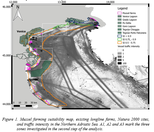
Based on the output of growth and deposition models, and on the multi-criteria analysis, it was possible to map areas characterized by high (0.75-0.90) and very high >0.90 suitability, with a spatial resolution of 1 km (Fig.1). Existing mussel cultivation areas, and perimeters of the Natura 2000 sites present in the area were also mapped, and superimposed to the layer representing traffic intensity in this maritime region. Two scenarios of increase of the surface covered by mussel leases were considered, namely +50% and doubling the surface within the region, and allocation distributed between three maritime areas selected within the portion of sea characterized by high and very high suitability, and marked with A1, A2 and A3 in Figure 1. Results of this exercise highlighted that the optimal allocation of the increase in mussel farms among A1, A2 and A3, and different shapes of the farms within these areas, can drive to different results when considering aquaculture suitability alone, and considering the effects produced by the farms on conservation and maritime traffic. Results are discussed with respect to the influence of weighting factors on the outcomes of the analysis and the perspectives for including additional regulation services, such as eutrophication control and carbon sequestration in the analysis.
Acknowledgements
DB carried out this research in the framework of the MSP-MED project “Towards the operational implementation of MSP in our common Mediterranean Sea”, EMFF Work Programme 2018 EASME tender EASME/EMFF/2018/1.2.1.5.
References
Brigolin, D., Porporato, E.M.D., Prioli, G., Pastres, R., 2017. Making space for shellfish farming along the Adriatic coast. ICES-Journal of marine science 74(6), 1540-1551.
European Community, 2014. Directive 2014/89/EU of the European parliament and of the council of 23 July 2014 establishing a Making space for shellfish farming along the Adriatic coast 1549
framework for maritime spatial planning. Off. J. Eur. Union L257 (Bruxelles).
Radiarta, I. N., Saitoh, S.-I., and Yasui, H. 2011. Aquaculture site selection for Japanese kelp (Laminaria japonica) in southern Hokkaido, Japan, using satellite remote sensing and GIS-based models. ICES – Journal of Marine Science, 68: 773–780.
Sanchez-Jerez, P., Karakassis, I., Massa, F., Fezzardi, D., Aguilar-Manjarrez, J., Soto, D., Chapela, R., Avila, P., Macias, J. C., Tomassetti, P., et al. 2016. Aquaculture’s struggle for space: the
need for coastal spatial planning and the potential benefits of Allocated Zones for Aquaculture (AZAs) to avoid conflict and promote sustainability. Aquaculture Environment Interactions, 8: 41–54.