MARITIME SPATIAL PLANNING PRINCIPLES AND SUSTAINABLE AQUACULTURE DEVELOPMENT: CASE STUDIES IN MADEIRA AND CANARY ISLANDS
Introduction
Accessibility to marine space is one of the major bottlenecks for the marine aquaculture sector. A methodology was defined for the implementation of MSP processes associated with marine aquaculture facilities in two Eastern Atlantic archipelagos: Madeira & the Canary Islands. The search for the most suitable marine locations is linked to 5 parameter clusters: oceanographic potential; environmental sensibility; restrictions related to marine conservation; Land-Sea interactions and avoidance of potential conflicts with extant maritime and coastal activities.
Materials and methods
A methodological approach has been designed to identify suitable marine areas with significant potential considering physical oceanographic parameters (temperature, depth…), minimizing impact on the marine environment (structured as Good Environmental Status defined by Marine Strategy Framework Directive 2008/56/EC), (in)compatibility with marine conservation (marine protected areas under the Natura 2000) and avoiding conflicts with operative maritime and coastal sectors (as coastal tourism, fisheries, aquaculture, maritime transport, etc.). We have applied this framework in the cases of Madeira (Portugal) and Canary Islands (Spain) in the Eastern Atlantic Ocean.
Results
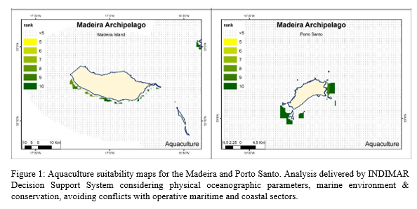
Aquaculture Suitability maps were developed based on the outputs of the Decision Support System of INDIMAR, which analyzed potential aquaculture production sites in relation with each of the 5 cluster parameters, introducing weights as appropriate calculated using an Analytical Hierarchy Process. The applied approach strikes a balance for all the five clusters reflecting on Ecosystem Based Management components that should be mirrored in the Maritime Spatial Planning strategy, including options with trade-offs regarding sectoral growth, conflict prevention and environmental protection and conservation.
Finally, results are compared with the extant aquaculture areas included in both the Madeira Zones Areas of Interest for Aquaculture that were adopted by the National Spatial Maritime Plan, based on the study delivered by Torres and Andrade (2010), and the Regional Plan of Management of the Canarian Aquaculture approved in 2018.
Acknowledgements
This research was funded through the Interreg project PLASMAR (MAC/1.1a/030) and finalized within the project PLASMAR+ (MAC2/1.1a/347) with the support of the European Union (EU), and mainly financed by the European Regional Development Fund (ERDF) and the INTERREG V-A Spain-Portugal MAC 2014–2020 (Madeira-Azores-Canarias).
References
Torres, C. and Andrade, C. (2010) Spatial decision Analysis Process for selection Marine Aquaculture suitable zones: The example of Madeira Island. Journal of Integrated Coastal Zone Management, 10(3): 321-330.