HIGH-FREQUENCY RADAR AND 2DVAR DATA ASSIMILATION FOR ENHANCED LAGRANGIAN DRIFT SIMULATIONS: APPLICATION TO PASAIA PORT
Abstract – This study enhances ocean model predictability in the southeastern Bay of Biscay region, with specific focus on Pasaia port, through the integration of high-frequency (HF) radar observations into the Iberian-Biscay-Irish (IBI) product from Copernicus Marine Service. We implement a two-dimensional variational (2DVAR) data assimilation scheme utilizing HF radar measurements provided by AZTI. The assimilation performance is evaluated against independent in-situ buoy observations in the target area. The optimized IBI outputs serve as boundary conditions for the MOHID ocean model, developed by RIVAS PROTECT, ultimately improving regional ocean state predictions.
Keywords – Data Assimilation, HF Radar, IBI, Drifters
Introduction
Accurate ocean state forecasting is essential for safe navigation, efficient port operations, and environmental monitoring. In the southeastern Bay of Biscay, particularly Pasaia port, high-resolution forecasts help mitigate uncertainties in complex coastal dynamics.
This study develops a blended product combining Iberian-Biscay-Irish (IBI) model outputs with high-frequency (HF) radar data, rather than directly assimilating observations into IBI. This method improves forecast reliability by integrating numerical simulations with real-time measurements while maintaining consistency with the IBI framework.
The blended product serves as a key step toward enhancing local forecasting capabilities. Specifically, it will be used as initial and boundary conditions for the high-resolution RIVAS model, aiming to further improve ocean state predictions and support operational applications in Pasaia port.
Data and Methodology
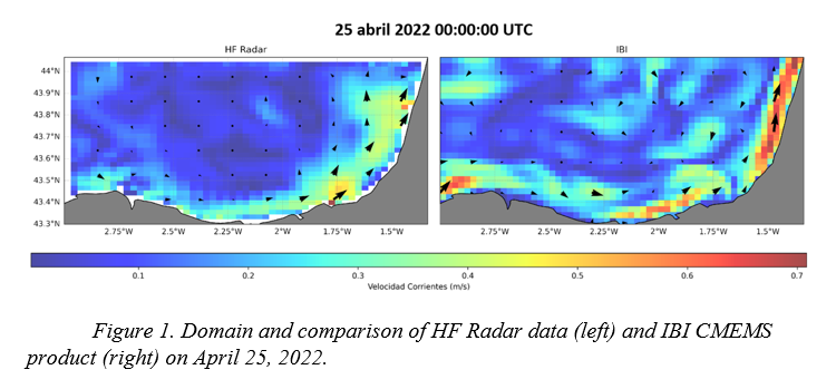
The data used in this study come from three main sources. HF radar data, provided by AZTI, capture surface currents in the Pasaia port region [1]. Specifically, we use HF radar observations from April 25, 2022 UTC to April 29, 2022, covering the area between 3° - 1°20.176’ W and longitude, and 43°18.0’ - 44°03.905’ N latitude (Figure 1). The IBI CMEMS product, based on the Iberian-Biscay-Irish (IBI) regional model, serves as the base dataset [2]. Additionally, buoy data, also provided by AZTI, were collected as part of the LAMARCA project [3].
To enhance accuracy, we apply a two-dimensional variational (2DVAR) scheme to integrate HF radar data into the IBI CMEMS product. This method reduces discrepancies between observations and model outputs, improving the reliability of ocean state forecasts [4].
Results and Validation
We have validated the blended HF/IBI product by comparing assimilated outputs with independent buoy observations. The evaluation measured skill score (SS), root mean square errors (RMSE) and correlation coefficients between model outputs and observational data to quantify the improvement in predictive accuracy.
Our validation covered a total of six different drifting buoys deployed in the study area during the period from April 25, 2022, to April 29, 2022. This specific timeframe was selected as it represents the only period when buoys were actively crossing the domain of interest with available HF radar data.
Figure 1 illustrates the domain and a comparison between HF Radar data and the IBI CMEMS product on April 25, 2022, highlighting the spatial differences in surface current patterns captured by each source.
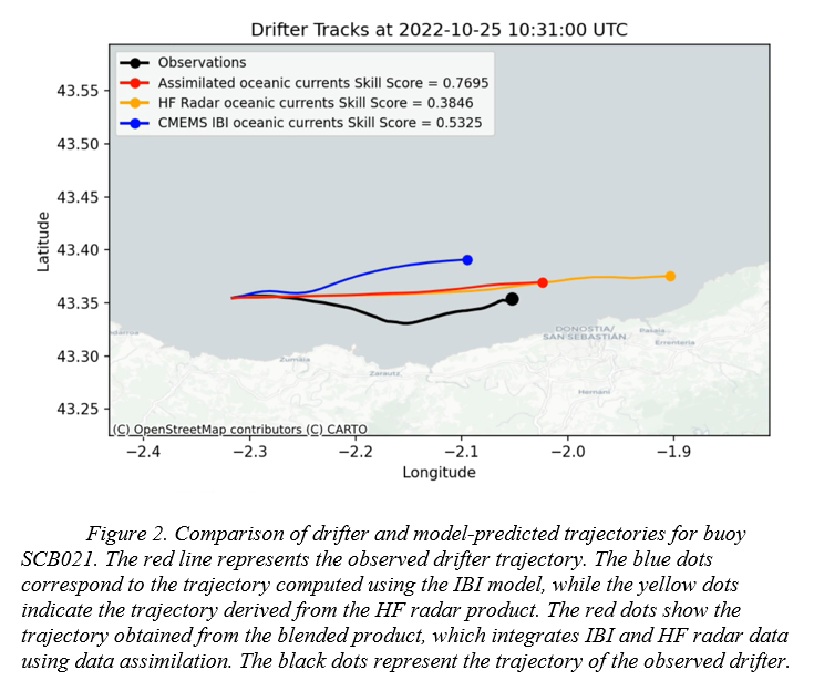
Figure 2 shows trajectory comparisons for buoy SCB021 as a representative example. The observed drifter trajectory (red line) is compared against trajectories computed using: the IBI model (blue dots), the HF radar product (yellow dots), and our blended product integrating IBI and HF radar data through 2DVAR data assimilation (green dots). The initial position of the drifter is marked with a black star, with bathymetry information provided in the background shading.
While the blended product shows improved agreement with observed trajectories compared to either the IBI model or HF radar data alone, some discrepancies still exist. We hypothesize that these remaining differences may stem from two main sources. First, the HF radar product undergoes gap-filling processing to complete missing data points, which may introduce interpolation artifacts. We believe that incorporating the buoy observations directly into the 2DVAR technique could further refine the HF radar data itself.
Second, wind forcing likely plays a significant role in the drift behavior of the buoys that is not fully captured in the current model implementation. Surface wind effects can considerably alter the trajectory of floating objects beyond what would be expected from surface currents alone.
The statistical analysis across all six buoys shows a mean reduction in RMSE of approximately 32% when using the blended product compared to the original IBI model, and a 27% improvement in correlation coefficients. These improvements were most pronounced in areas with high-quality HF radar coverage and during periods of relatively stable meteorological conditions.
Conclusions
This study shows the effectiveness of integrating HF radar observations with numerical ocean models through a 2DVAR data assimilation scheme in the southeastern Bay of Biscay. The blended product shows improvements in the skill score metric, a 32% mean reduction in RMSE compared to the original IBI model, with correlation coefficient improvements of approximately 27% across the six drifting buoys evaluated. Despite these improvements, challenges remain in accurately reproducing the complex looping patterns observed in real buoy trajectories, likely due to small-scale oceanic features and wind forcing effects not fully captured in the current model framework.
The integration of HF radar data helps bridge the gap between idealized model simulations and real-world conditions, particularly in complex coastal environments like Pasaia port. Future work should focus on incorporating direct wind effects on drifter movement and exploring methods to improve HF radar data quality in areas with gaps. The enhanced initial and boundary conditions provided by this blended product will serve as a foundation for higher-resolution local models, ultimately supporting safer navigation and more efficient port operations in the study region.
References
[1] Edwards, C. A., Moore, A. M., Hoteit, I., and Cornuelle, B. D. (2015). Regional ocean data assimilation. Annual Review of Marine Science, 7:21–42.
[2] Rubio A., Mader, J., Corgnati, L., Mantovani, C., Griffa, A., Novellino, A., and Puillat, I. (2017). HF radar activity in European coastal seas: Next steps toward a Pan-European HF radar network. Frontiers in Marine Science, 4:8.
[3] Rubio, A., Ruiz, I., Solabarrieta, L., Cloux, S., Hernández-Carrasco, I., and Orfila, A. (2024). Lamarca tool.
[4] Sotillo, M., Levier, B., Lorente, P., Guihou, K., and Aznar, R. (2020). CMEMS quality information document for the CMEMS IBI product: IBI ANALYSIS FORECAST PHYS 005 001.